It was one of those thrown-together trips. You know the kind. You grab your stuff, hit the road, and hope you land somewhere great.
It wasn’t the trip I had envisioned for my August overland excursion, though. For months I had been planning a weeklong overland journey through western Idaho with a friend of mine. A week before the departure date, the transmission on his FJ Cruiser grenaded (Toyotas, am I right?). Down a follow vehicle, I was left scrambling.
I considered taking on the Idaho trip alone. Since I live, work, and spend most of my time alone, the cache ‘getting away from it all’ by myself was lost on me. Putting the idea of a solo trip squarely in my rearview mirror, I opened my contacts list.
None of my other overlanding friends could join me — kids, vacation, work, or vehicle repairs prevented everyone else from joining. So, I sought someone to ride shotgun.
Eventually, my buddy Nick agreed to join me on a journey that I billed as a ‘TBD Central Oregon excursion.’
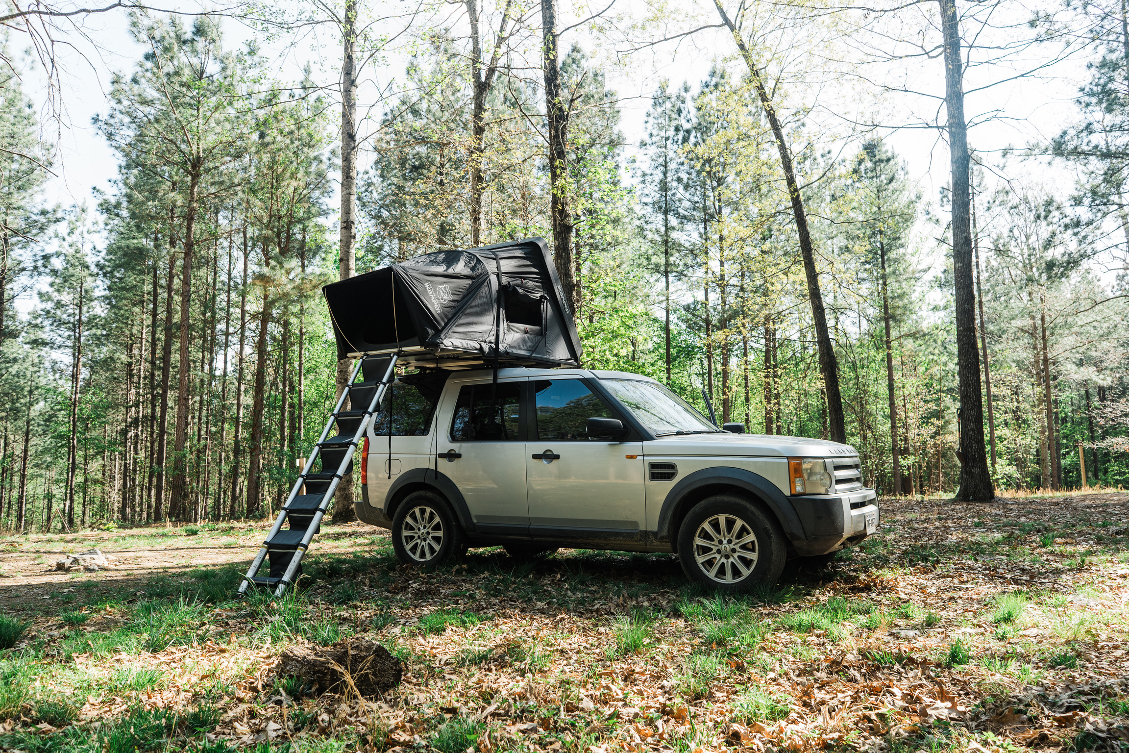
On a Thursday afternoon, Nick arrived at my house. A gentle drizzle began to fall as we haphazardly threw his stuff into the pile of gear in the bed of my Gladiator. And we hit the road.
Winging it
There’s a real sense of freedom in hitting the road with no destination in mind. There’s a real sense of dread, too — at least for me.
I had everything onboard to survive virtually anywhere for several days. That’s not what gets to me. It was the worry of landing somewhere — how do I put this — lame that sat heavy in the pit of my stomach.
When we departed, visions of making camp at sunset next to a roaring river deep inside a swath of Federal land replayed in my head. Simultaneously, I was haunted by the idea of settling for some junky campground at midnight after having exhausted all other options.
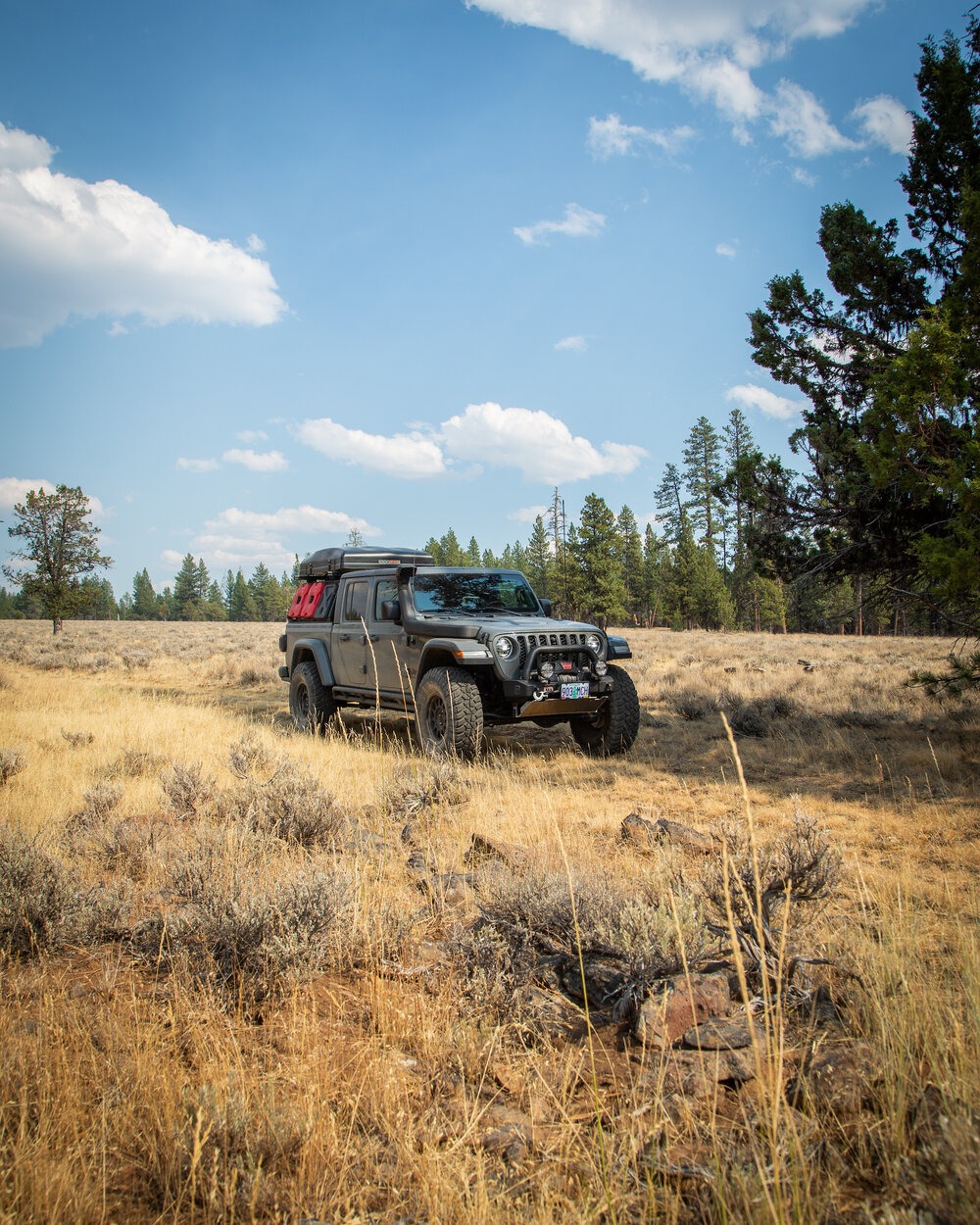
Photo: Nick Jaynes
With my brand-new Garmin Overlander suction-cupped to the inside of the windshield of my Jeep, I instructed Nick to play navigator and find us a spot. I piloted the rig onto I-84 East out of Portland. I set the cruise control for 72 miles per hour. And Nick dived into his role as digital scout.
After pawing at the Overlander screen for just a few minutes, Nick cheerily piped up.
“I think I found a spot,” he said. “It’s on some Bureau of Land Management (BLM) land. It’s next to a river.”
“Perfect,” I said.
Nick tapped the screen at the spot, added it as a waypoint, and hit the ‘start navigation’ arrow icon. The Overlander’s screen flopped from the Explore app and the Drive app and turn-by-turn navigation automatically started. It was easy as that.
Our estimated arrival time was four and a half hours, which put us rolling up to the riverside just after sunset. This wasn’t ideal, but not terrible.
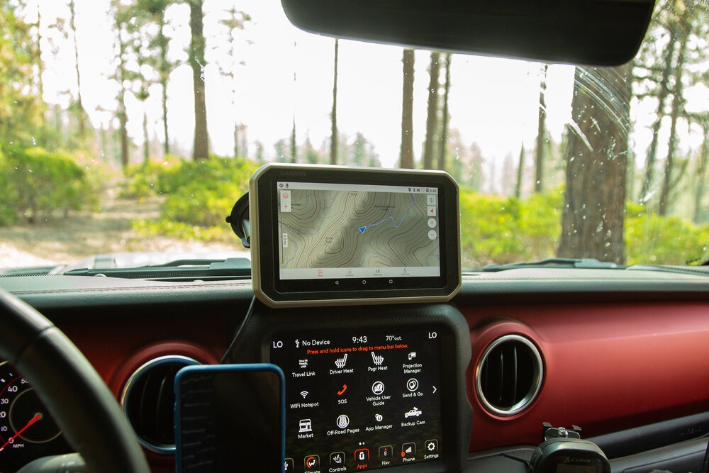
Photo: Nick Jaynes
A couple hours into our drive, well into the central part of the state, we turned off the freeway and took one rural highway after another as we headed southward. We weaved our way through the brush-covered canyons, gaining in elevation.
The sun began to set to our right and created an ominous orange-red glow through the lingering smoke from faroff wildfires. We faithfully followed the Garmin up through the canyonlands.
Don’t we have a deal?
Maybe an hour off the highway, around one seemingly innocuous bend in the road, we spotted a flock of grouse huddled on the highway. We were remote. Though since we were still on pavement, I thought nothing of the flock. Unfazed, we barreled toward the birds at 60 mph.
A twinge of panic hit me about three meters away from the flock. I realized they weren’t scattering, as I had expected. Instinct kicked in — for them and me — at the last moment. I had only a second to dab the brakes before colliding with them. Of the twelve-or-so of the softball-sized birds, most cleared the truck in time. Three or four bounced off the front of the Jeep. And, as I looked in the rearview mirror, I could see at least one land motionless on the dusky strip of highway tarmac behind me.
Flashes of the scene from “Seinfeld” in which George Costanza hits a flock of pigeons with his car flashed through my brain.
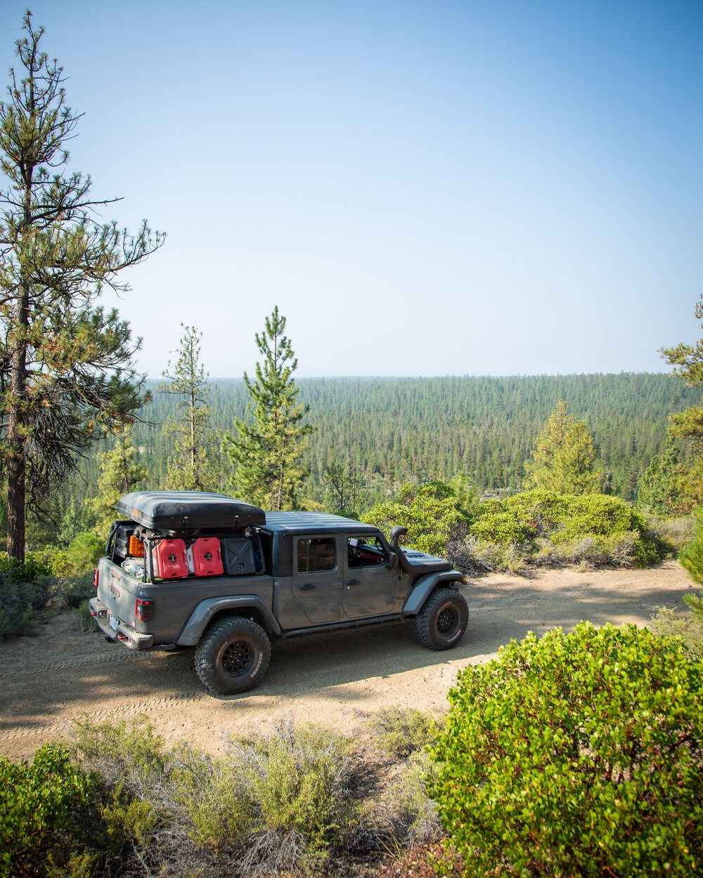
Photo: Nick Jaynes
“It’s not my fault, is it? Don’t we have a deal with the pigeons?” George later asked Jerry back at the diner.
I was asking Nick similar questions.
I couldn’t believe it. How did the grouse not get off the road in time? How can they live next to a highway and not know to get out of the way of the large, loud Jeep? The Gladiator is incredibly capable. But stealth is not one of its capabilities.
A fluke accident, I told myself. And I put it out of my mind.
Perhaps four miles later, it happened again. I hit another flock. Neither Nick nor I have ever seen anything like it. Weeks later, I still don’t understand it.
Crafty ranchers
Not long after sunset, we pulled off the canyon highway and onto a steep two-track. It snaked up off the canyon floor and up into the surrounding hills. The Garmin Overlander was still leading us — turn by turn — to our riverside camp spot, now just about a mile away.
We crested the hill and rounded a corner to find a fence with a “no trespassing, private property” sign hung on it.
Nick and I were at a loss.
“I thought you said this was BLM land?”
“It is!” Nick shouted back exasperated. He grabbed the Overlander off its magnetic cradle. He opened the ‘Explore’ app and zoomed in.
As far as we could surmise, a rancher must have bought maybe a quarter-acre rectangle of land directly on the public road. This allowed him to gate it off. He’d secured a tiny island of private land strategically placed so that he could essentially commandeer an entire swath of public land for his own private use. Because of the topography, there was no other way to access the rest of the once-public road. Crafty bastard.
Feeling defeated, we searched on the map for other locations. Icons on the Explore map indicated a few State Forest campgrounds not more than 10 minutes down the road.
Since it was August, we assumed the campgrounds would be fully booked. Even if there were a spot, we couldn’t bring ourselves to camp at a public campground anyhow. So we found a flat spot back off the two-track, parked the truck, and set up camp for the night.
The next morning, my puppy woke up with the sun. Unable to get back to sleep, I decided to take him for a walk and investigate our wouldbe riverside campsite.
Probably 200 yards down the road past the gate, we came to the junction where the two-track veered left off the road and down toward the river. Forty yards from there, the two-track took a steep dive down the hill — maybe a 20-degree decline — toward the river.
Photo: Nick Jaynes
I stood at the lip of the hill and studied the track, as it twisted down to the river.
The steepness of the slope threw me off at first. I realized it wasn’t anything my Gladiator’s brakes couldn’t handle. The gully at the bottom of the hill before the river is what spooked me. From that vantage point, I didn’t know how steep it’d be. With my land anchor sitting back in my home garage, and without a second vehicle to pull me out should I get stuck, I decided not to attempt to reach the river. My insides burned.
Some day, with a few buddies and their rigs in tow, I will attempt to reach that river. I will not be bested by that wiley rancher or a distant gully.
Getting to know Garmin
After breakfast, Nick and I packed up the Gladiator, climbed into the cab, and poked around again on the Garmin. We needed to pick that day’s destination.
On the Explore app, we found another riverside spot on some BLM — again several hours from our current spot. We made it a waypoint and activated turn-by-turn navigation. It was three hours away, near the Ochoco National Forest. We cued up some Johnny Cash on the stereo and settled in for the drive.
The three-hour drive gave Nick and me time to really dig through the Overlander’s features.
Though the Overlander is ostensibly a turn-by-turn off-road navigation tool, it’s more than simply that. You can record tracks, check your vehicle’s pitch and roll, monitor an altimeter, barometer, elevation, and current and maximum elevation, pair another Garmin device to enable sending text messages through the Overlander — among other features — all through the large touchscreen.
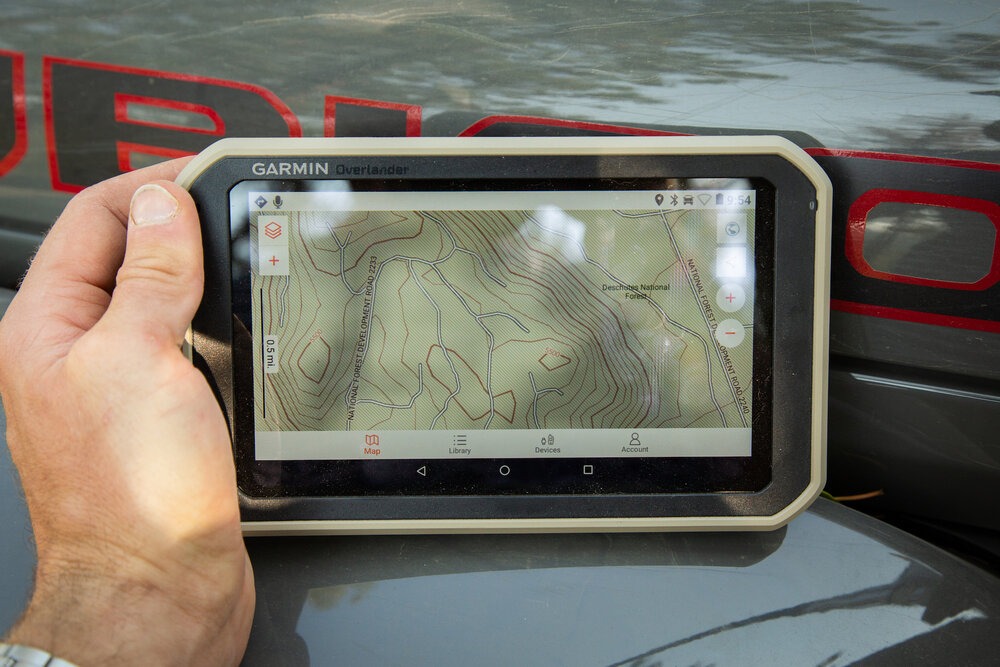
Photo: Nick Jaynes
If you’d asked me six week ago if I might need, let alone use, any of these features, I may have scoffed at you. That’s because I have a collection of gadgets that already do most of those things.
I can run Gaia through the Jeep’s 8.4-inch Uconnect touchscreen by way of Apple CarPlay. Uconnect’s Off-Road Pages app has both a pitch, roll, and altimeter function. Just to the left of that, high-definition maps are close at hand on my iPad Mini on which I’ve installed the onX Offroad app. So, across several devices I have most of these features.
Except — and this is a big except — I never had good turn-by-turn off-road navigation.
I’ve never gotten Gaia to generate turn-by-turn directions on the fly. The onX app doesn’t even offer turn-by-turn. My Jeep’s built-in navigation has few off-the-beaten-path roads on file. Trying to cue it up in the backcountry returns the equivalent of a shrug emoji. And Google Maps only works if you have a cell signal.
Discovering the simplicity with which I could initiate turn-by-turn directions from seemingly any point to virtually any other point was intoxicating. I was immediately won over by the Overlander.
Having charmed me with that standout feature, I warmed to the others.
The Off-Road Pages app on Uconnect takes a lot of time to load. The pitch, roll, and altimeter functions take longer still. Meanwhile, the Garmin’s features were accessible in seconds. The onX maps might be higher resolution than the Overlander’s. But without a cell signal or the foresight to preemptively download swaths of high-definition chunks of map ahead of time, one painstaking five-mile lump at a time, those onX maps are essentially nonexistent.
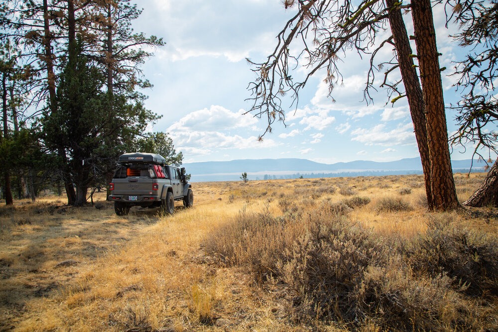
Photo: Nick Jaynes
Meanwhile, Garmin Overlander has what you need already onboard and it’s ready to use — even deep in the backcountry miles from even the most scant cell signal.
Shots in the dark
En route to our second riverside spot, Nick and I forded some water crossings, traversed some seemingly ancient volcanic rock-strewn two-tracks, and chainsawed a few fallen trees that blocked our path.
Diverted by another crafty rancher and his BLM land-blocking barriers, we eventually found the river. We pitched our tents, swam in the calm, cool waters with my puppy, made a hearty meal and bedded down for the night.
Not long after we turned in for the night, two pairs of headlights illuminated the dry grasses around camp. The sounds of barely-muffled engines echoed rock wall across the river.
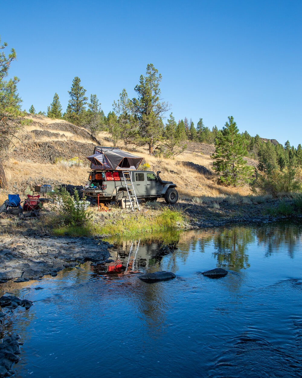
Photo: Nick Jaynes
Peering through my rooftop tent’s window, I saw a group of folks in pickup trucks glaring at us. Neither Nick nor I moved. We could hear their muffled chatter, as they shined their spotlights at us, over our camp in the dark. We didn’t let them disturb us. Eventually, they gave up and drove back up the track away from the river. That’s when the gunfire started from atop the bluff behind us.
Just a couple shots that rang out in the dark at first. Then a barrage. It didn’t sound — or feel — like they were firing at us. Lord knows what they were shooting at, if anything.
Weary from a day of driving and log splitting, I managed to fall asleep despite the sharp cracks of gunfire.
Turn-by-turn all over again
The next morning, there were no sounds of the trigger-happy band of ne’er do wells. So we carried on as usual. We made breakfast and enjoyed our coffee by the riverside. We packed up, piled in the truck, and picked another spot for the Overlander to take us to. It was easy.
Actually, it wasn’t easy. Being diverted by crafty rancher’s fences wasn’t easy. Chopping fallen trees wasn’t easy. Nor was enduring late night artillery fire easy.
But the Overlander made winging it easy. Moreover, it made it fun.
I really love overlanding and everything it entails. The journeys are the pleasure, though. And the thrill of picking a place on a map you’ve never considered before and getting there is second to none. Now, having used the Garmin Overlander, I prefer to have a device tell me how to get there.
Header image credit: Nick Jaynes